Latest storm news says low pressure near East Sea has strengthened into tropical storm Ampil.
According to the latest storm information from the Philippine weather agency PAGASA on August 13, the low pressure near the East Sea that formed over the weekend has strengthened into storm Ampil.
At 3:00 a.m. on August 13, the latest storm Ampil was 1,570 km east-northeast of Northern Luzon, with maximum sustained winds of 65 km/h near the center of the storm, gusting up to 80 km/h.
This storm near the East Sea is moving slowly northeast.
The latest storm information from the Joint Typhoon Warning Center (JTWC) of the US Air Force and Navy said that the low pressure near the East Sea strengthened into storm Ampil at 7:00 p.m. on August 12. Ampil is Japan’s seventh storm.
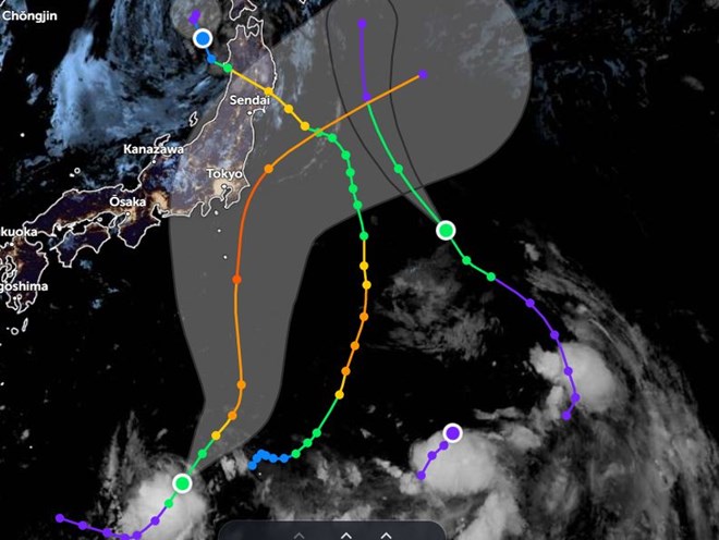
Ampil is currently 1,224 km south of Yokosuka, Japan and has been moving northeast at 19 km/h for the past 6 hours.

The JTWC forecast states that, based on the average speed of intensification, Ampil is expected to reach wind speeds of 140 km/h over the next 2 days as it moves north of Iwo To Island.
After 2 days, Ampil will interact with a weakening upper-level low (ULL) southeast of Honshu, leading to reduced wind shear and potentially facilitating the development of the latest storm.
This environment, coupled with the movement over the sea with a 2-3 degree Celsius increase in surface temperature to 30-31 degrees Celsius, will cause the latest storm in the western Pacific to intensify over the next 2 to 3 days.
JTWC forecasters predict that Ampil will reach 185 km/h in 3 days. During this time, the storm is likely to approach or sweep across Honshu, Japan. It is not yet certain whether Ampil will make landfall in Japan.
In addition to Ampil, a storm near the East Sea, there are 2 other storms and a tropical depression in the western Pacific Ocean.
On the morning of August 12, local time, Typhoon No. 5 Maria made landfall in Iwate Prefecture, Japan, and is moving toward the Sea of Japan. Meanwhile, Tropical Storm Son Tinh is approaching Japan from the sea off the east coast of the country.
According to the latest storm information from the Joint Typhoon Warning Center (JTWC), Typhoon No. 6 Son Tinh is 906 km east of Yokosuka, Japan, and has been moving northwest at a speed of 24 km/h in the past 6 hours.
Typhoon Son Tinh is forecast to continue moving northwest and then turn north within 24 to 36 hours. Typhoon No. 6 is expected to dissipate in the next 36 hours southeast of Hokkaido.