Typhoon Shanshan tracks west-northwestward over Philippine Sea early Aug. 26. Landfall over Kagoshima Prefecture, Japan, early Aug. 29.
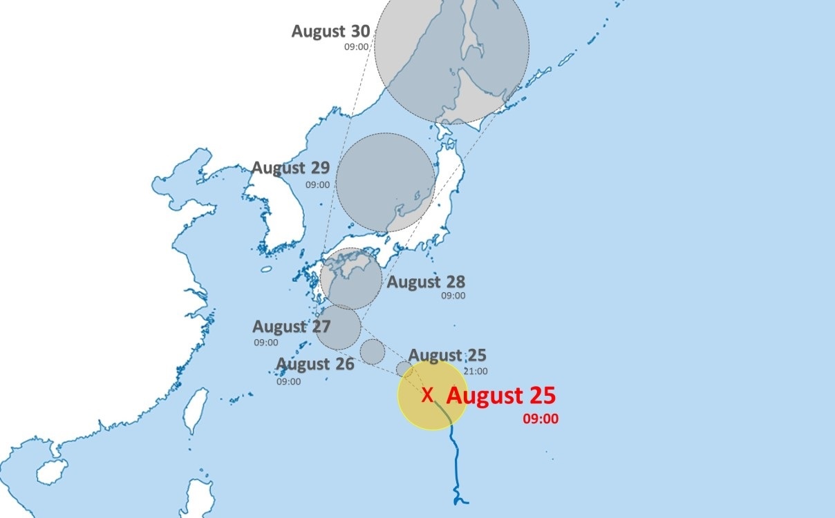
Typhoon Shanshan is tracking northwestward across the Philippine Sea early Aug. 25. As of 12:00 JST, the system’s center of circulation was approximately 770 km (479 miles) south-southeast of Sasebo.
Forecast models indicate that the weather system will strengthen further as it tracks generally northwestward away from Iwo Jima through early Aug. 28 before turning sharply to track north-northeastward and make landfall over Kagoshima Prefecture early Aug. 29. After landfall, the system is likely to weaken into a tropical storm and make another landfall over Ehime Prefecture early Aug. 30 before continuing northeastward and making a subsequent landfall over Okayama Prefecture late Aug. 30. Shanshan is forecast to weaken further but remain at tropical storm strength as it tracks northeastward across Hyogo and Kyoto prefectures before exiting into the Sea of Japan early Aug. 31. Some uncertainty remains in the track and intensity forecast, and changes could occur in the coming days.
As of early Aug. 26, the Japan Meteorological Agency (JMA) has issued a bulletin warning that the typhoon will track northward and approach western Japan and the Amami region after Aug. 27, resulting in strong winds, high waves, landslides, and flooding. Heavy rainfall of 15 cm (6 inches) in the Tokai region, 12 cm (5 inches) in the Kinki region, and 10 cm (4 inches) in the Shikoku region are forecast through early Aug. 27. Swells and heavy seas are likely across western Japan; waves of up to 9 meters (30 feet) are forecast over southern Kyushu Aug. 27-28 and in Shikoku Aug. 28. Authorities will likely issue new warnings or update existing advisories throughout the system’s progression in the coming days.

Sustained heavy rainfall could trigger flooding in low-lying areas and those with easily overwhelmed drainage systems. If weather conditions prove hazardous, localized evacuations, flash flooding, and landslides are possible.
Inclement weather could trigger localized business, transport, and utility disruptions and render some bridges or roadways impassable. Flight disruptions at regional airports and temporary port closures are also possible. Stagnant pools of water during and after flooding increase insect- and waterborne diseases, such as dengue fever, cholera, and malaria. Exposure to raw sewage and other hazardous materials mixed with floodwaters poses a serious health threat.