Date & time
Aug 26, 2024 16:23:00 UTC – 55 minutes ago
Local time at epicenter
Tuesday, Aug 27, 2024, at 12:23 am (GMT +8)
Status
Preliminary (automatic detection)
Magnitude
3.4
Depth
25 km
Epicenter latitude / longitude
17.6°N / 122.56°E![]() Philippines
Philippines
Seismic antipode
17.6°S / 57.44°W![]() Brazil
Brazil
Shaking intensity
III Weak shaking near epicenter
Felt
0 reports
Primary data source
PHIVOLCS (Philippine Institute of Volcanology and Seismology)
Nearest volcano
Cagua (83 km / 52 mi)
Weather at epicenter at time of quake
Overcast Clouds  29.1°C (84 F), humidity: 72%, wind: 2 m/s (4 kts) from NW
Estimated seismic energy released
7.9 x 10⁹ joules (2.21 megawatt hours, equivalent to 1.9 tons of TNT) | about seismic energy
NEARBY PLACES
The closest larger town where the quake might have been felt is San Jose, a town with 4,500 inhabitants in the Philippines, in 80 km (50 mi) distance northwest of the epicenter. People likely experienced very weak shaking there. In the capital of the ![]() Philippines, Manila, 373 km (232 mi) away from the epicenter, the earthquake could not be felt.
Philippines, Manila, 373 km (232 mi) away from the epicenter, the earthquake could not be felt.
The following table shows some of the places that might have been affected (or not) by the shaking.
DISTANCE
PLACE
MAX. SHAKING INTENSITY(*)
REGION
COUNTRY
80 km (50 mi)
NW of epicenter
San Jose
(pop: 4,530)
II: Very weak
Cagayan, Cagayan Valley
![]() Philippines
Philippines
86 km (53 mi)
W of epicenter
Cabagan
(pop: 25,300)
I: Not felt
Isabela, Cagayan Valley
![]() Philippines
Philippines
87 km (54 mi)
SW of epicenter
Ilagan
(pop: 72,400)
I: Not felt
Isabela, Cagayan Valley
![]() Philippines
Philippines
87 km (54 mi)
SW of epicenter
Tumauini
(pop: 3,570)
I: Not felt
Isabela, Cagayan Valley
![]() Philippines
Philippines
89 km (55 mi)
W of epicenter
Tuguegarao City
(pop: 115,100)
I: Not felt
Cagayan, Cagayan Valley
![]() Philippines
Philippines
90 km (56 mi)
SW of epicenter
Angela
(pop: 12,400)
I: Not felt
Isabela, Cagayan Valley
![]() Philippines
Philippines
91 km (57 mi)
W of epicenter
Nattapian
(pop: 11,900)
I: Not felt
Cagayan, Cagayan Valley
![]() Philippines
Philippines
92 km (57 mi)
W of epicenter
Solana
(pop: 71,500)
I: Not felt
Cagayan, Cagayan Valley
![]() Philippines
Philippines
94 km (58 mi)
NW of epicenter
Taguing
(pop: 2,080)
I: Not felt
Cagayan, Cagayan Valley
![]() Philippines
Philippines
95 km (59 mi)
NW of epicenter
Gonzaga
(pop: 7,230)
I: Not felt
Cagayan, Cagayan Valley
![]() Philippines
Philippines
98 km (61 mi)
SW of epicenter
Gamu
(pop: 5,550)
I: Not felt
Isabela, Cagayan Valley
![]() Philippines
Philippines
99 km (61 mi)
SW of epicenter
Santo Domingo
(pop: 2,640)
I: Not felt
Isabela, Cagayan Valley
![]() Philippines
Philippines
99 km (61 mi)
W of epicenter
Rizal
(pop: 5,290)
I: Not felt
Kalinga, Cordillera
![]() Philippines
Philippines
102 km (63 mi)
NW of epicenter
Palagao Norte
(pop: 2,950)
I: Not felt
Cagayan, Cagayan Valley
![]() Philippines
Philippines
106 km (66 mi)
W of epicenter
Quezon
(pop: 9,490)
I: Not felt
Isabela, Cagayan Valley
![]() Philippines
Philippines
106 km (66 mi)
NW of epicenter
Santa Ana
(pop: 6,320)
I: Not felt
Cagayan, Cagayan Valley
![]() Philippines
Philippines
107 km (66 mi)
NW of epicenter
Pattao
(pop: 3,220)
I: Not felt
Cagayan, Cagayan Valley
![]() Philippines
Philippines
110 km (68 mi)
W of epicenter
Santo Niño
(pop: 4,920)
I: Not felt
Cagayan, Cagayan Valley
![]() Philippines
Philippines
112 km (69 mi)
NW of epicenter
Magapit
(pop: 11,200)
I: Not felt
Cagayan, Cagayan Valley
![]() Philippines
Philippines
112 km (70 mi)
W of epicenter
Dagupan
(pop: 2,310)
I: Not felt
Cagayan, Cagayan Valley
![]() Philippines
Philippines
113 km (70 mi)
SW of epicenter
Roxas
(pop: 16,600)
I: Not felt
Isabela, Cagayan Valley
![]() Philippines
Philippines
114 km (71 mi)
NW of epicenter
Lasam
(pop: 6,350)
I: Not felt
Cagayan, Cagayan Valley
![]() Philippines
Philippines
115 km (71 mi)
SW of epicenter
Minante Segundo
(pop: 6,700)
I: Not felt
Isabela, Cagayan Valley
![]() Philippines
Philippines
117 km (72 mi)
W of epicenter
Piat
(pop: 5,960)
I: Not felt
Cagayan, Cagayan Valley
![]() Philippines
Philippines
117 km (72 mi)
W of epicenter
Tabuk
(pop: 27,000)
I: Not felt
Kalinga, Cordillera
![]() Philippines
Philippines
117 km (73 mi)
SW of epicenter
San Manuel
(pop: 9,870)
I: Not felt
Isabela, Cagayan Valley
![]() Philippines
Philippines
122 km (76 mi)
W of epicenter
Paracelis
(pop: 4,230)
I: Not felt
Mountain, Cordillera
![]() Philippines
Philippines
126 km (78 mi)
SW of epicenter
San Guillermo
(pop: 3,930)
I: Not felt
Isabela, Cagayan Valley
![]() Philippines
Philippines
127 km (79 mi)
NW of epicenter
Allacapan
(pop: 3,650)
I: Not felt
Cagayan, Cagayan Valley
![]() Philippines
Philippines
129 km (80 mi)
NW of epicenter
Aparri
(pop: 33,200)
I: Not felt
Cagayan, Cagayan Valley
![]() Philippines
Philippines
129 km (80 mi)
SW of epicenter
Alicia
(pop: 24,700)
I: Not felt
Isabela, Cagayan Valley
![]() Philippines
Philippines
131 km (81 mi)
SW of epicenter
San Mateo
(pop: 16,200)
I: Not felt
Isabela, Cagayan Valley
![]() Philippines
Philippines
131 km (82 mi)
SW of epicenter
Butigui
(pop: 2,220)
I: Not felt
Mountain, Cordillera
![]() Philippines
Philippines
134 km (84 mi)
NW of epicenter
Binalan
(pop: 2,280)
I: Not felt
Cagayan, Cagayan Valley
![]() Philippines
Philippines
142 km (88 mi)
SW of epicenter
Ramon
(pop: 36,300)
I: Not felt
Isabela, Cagayan Valley
![]() Philippines
Philippines
145 km (90 mi)
NW of epicenter
Cabaritan East
(pop: 9,350)
I: Not felt
Cagayan, Cagayan Valley
![]() Philippines
Philippines
148 km (92 mi)
SW of epicenter
Jones
(pop: 5,230)
I: Not felt
Isabela, Cagayan Valley
![]() Philippines
Philippines
148 km (92 mi)
SW of epicenter
Santiago
(pop: 108,400)
I: Not felt
Isabela, Cagayan Valley
![]() Philippines
Philippines
158 km (98 mi)
SW of epicenter
Saguday
(pop: 7,460)
I: Not felt
Quirino, Cagayan Valley
![]() Philippines
Philippines
373 km (232 mi)
SW of epicenter
Manila
(pop: 1,600,000)
: Not felt
Capital, National Capital
![]() Philippines
Philippines
COMPARE QUAKE DATA
Data for the same earthquake as reported by different agencies
The more agencies report about the same quake and post similar data, the more confidence you can have in the data. It takes normally up to a few hours until earthquake parameters are calculated with near-optimum precision.
MAG
DEPTH
TIME GMT
2024-08-26
EPICENTER
AGENCY
3.4
25 km
16 mi
16:23:00
042 km N 43° E of Divilacan (Isabela)
PHIVOLCS (Philippine Institute of Volcanology and Seismology)
3.4
25 km
16 mi
16:23:04
Luzon, Philippines
0 km (0 mi) epicenter difference with PHIVOLCS
EMSC (European-Mediterranean Seismological Centre)
EARTHQUAKE STATISTICS
Average number of earthquakes
Based on data from the past 54 years and our earthquake archive back to 1900, there are about 117 quakes on average per year in the area near the epicenter of this quake (within 100 km/61 mi):
Mag. 6 or higher: 0.04 quakes per year (or 1 quake every 25 years)
Mag. 5 or higher: 0.63 quakes per year (or 1 quake every 1.6 years)
Mag. 4 or higher: 3.3 quakes per year
Mag. 3 or higher: 27.6 quakes per year
Mag. 2 or higher: 106 quakes per year (or 8.8 quakes per month)
Mag. 1 or higher: 117 quakes per year (or 9.7 quakes per month)
The area where this quake occurred has a high level of seismic activity. It has had at least 5 quakes above magnitude 6 since 1900, which suggests that larger earthquakes of this size occur infrequently, probably on average approximately every 20 to 25 years.
PREVIOUS QUAKES IN THE SAME AREA OF THIS EARTHQUAKE
The earthquake occurred 9 days after a magnitude 3.4 earthquake had hit on Sunday, Aug 18, 2024, at 08:59 am (GMT +8 local time) in 19.3 km (12 mi) distance to the southeast:
Mag. 3.4 earthquake 037 km N 70° E of Divilacan (Isabela) – Aug 18, 2024 – 9 days ago
The largest quake near the epicenter of this quake during the 10 years before was an event of magnitude 7.0. It had occurred 2 years earlier, on Wednesday, Jul 27, 2022, at 08:43 am local time (Asia/Manila GMT +8) in Cordillera, ![]() Philippines:
Philippines:
Mag. 7.0 earthquake Abra – Ilocos, Philippines – Jul 27, 2022 – 2 years ago
The strongest-ever (since 1900) recorded quake in this area measured magnitude 7.7. It had occurred 34 years ago earlier, on Monday, Jul 16, 1990, at 03:26 pm local time (Asia/Manila GMT +8) in Central Luzon, ![]() Philippines:
Philippines:
Mag. 7.7 earthquake Luzon – Philippines – Jul 16, 1990 – 34 years ago
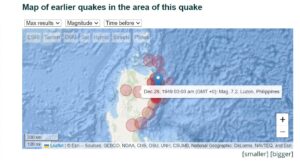
Below is a list and map of (larger or recent) quakes that had occurred near the area of the epicenter before this earthquake (within up to 100 km/61 mi distance, up to 300 km/183 mi for very large quakes above mag. 7). Filter the list to limit the number to show, by magnitude or time before.
DATE AND TIME
MAG
DEPTH
DISTANCE
LOCATION
DETAILS
MAP
Aug 25, 11:20 pm (Manila)
1 day 2 hours ago
1 day 1 hours earlier
3.0
34 km
19 km (12 mi) to the W
![]() Philippine Sea, 71 km east of Tuguegarao City, Philippines I FELT IT
Philippine Sea, 71 km east of Tuguegarao City, Philippines I FELT IT
Info
Aug 18, 08:59 am (GMT +8)
9 days ago
3.4
30 km
19 km (12 mi) to the SE
![]() Philippine Sea, 98 km east of Tuguegarao City, Philippines
Philippine Sea, 98 km east of Tuguegarao City, Philippines
Info
Aug 5, 03:53 am (GMT +8)
3 weeks ago
4.0
23 km
19 km (12 mi) to the SE
![]() 044 km N 69° E of Divilacan (Isabela)
044 km N 69° E of Divilacan (Isabela)
Info
Aug 1, 12:39 am (GMT +8)
4 weeks ago
3.7
24 km
19 km (12 mi) to the SE
![]() 042 km N 70° E of Divilacan (Isabela)
042 km N 70° E of Divilacan (Isabela)
Info
Jul 31, 12:39 pm (GMT +8)
4 weeks ago
3.6
10 km
14 km (8.6 mi) to the SE
![]() Luzon, Philippines
Luzon, Philippines
Info
Jul 31, 10:10 am (Manila)
4 weeks ago
3.5
33 km
23 km (14 mi) to the W
![]() Philippine Sea, 67 km east of Tuguegarao City, Philippines
Philippine Sea, 67 km east of Tuguegarao City, Philippines
Info
Jul 16, 07:19 am (Manila)
6 weeks ago
4.7
10.7 km
18 km (11 mi) to the SW
![]() 47 km N of Dicabisagan, Philippines 1 report
47 km N of Dicabisagan, Philippines 1 report
Info
May 9, 2023 01:13 am (Manila)
1 year 16 weeks ago
4.6
35 km
30 km (19 mi) to the SW
![]() Luzon, Philippines 2 reports
Luzon, Philippines 2 reports
Info
May 7, 2023 07:36 pm (Manila)
1 year 16 weeks ago
5.2
32 km
30 km (18 mi) to the SW
![]() Luzon, Philippines 14 reports
Luzon, Philippines 14 reports
Info
May 4, 2023 01:56 pm (Manila)
1 year 17 weeks ago
4.8
10.5 km
29 km (18 mi) to the W
![]() Luzon, Philippines 6 reports
Luzon, Philippines 6 reports
Info
May 4, 2023 09:22 am (Manila)
1 year 17 weeks ago
4.9
10.6 km
28 km (18 mi) to the W
![]() 49 Km N of Dicabisagan, Philippines 3 reports
49 Km N of Dicabisagan, Philippines 3 reports
Info
May 4, 2023 08:49 am (Manila)
1 year 17 weeks ago
5.4
19 km
27 km (17 mi) to the SW
![]() Luzon, Philippines 34 reports
Luzon, Philippines 34 reports
Info
Apr 23, 2023 05:21 pm (Manila)
1 year 18 weeks ago
4.9
10.3 km
28 km (17 mi) to the W
![]() 47 Km ESE of Lapi, Philippines
47 Km ESE of Lapi, Philippines
Info
Apr 23, 2023 05:19 pm (Manila)
1 year 18 weeks ago
5.3
34 km
30 km (19 mi) to the W
![]() 47 Km NNW of Dicabisagan, Philippines 30 reports
47 Km NNW of Dicabisagan, Philippines 30 reports
Info
Jul 27, 2022 08:43 am (Manila)
2 years ago
7.0
34 km
185 km (115 mi) to the W
![]() Abra, Cordillera, 46 km east of Vigan, Ilocos Sur, Ilocos, Philippines 2352 reports
Abra, Cordillera, 46 km east of Vigan, Ilocos Sur, Ilocos, Philippines 2352 reports
Info
Jan 17, 2019 08:22 pm (GMT +8)
6 years ago
4.8
40 km
82 km (51 mi) to the NE
![]() PHILIPPINE ISLANDS REGION
PHILIPPINE ISLANDS REGION
Info
Jan 6, 2019 04:42 am (GMT +8)
6 years ago
4.8
52 km
41 km (25 mi) to the NE
![]() – 85km SE of Casambalangan, Philippines
– 85km SE of Casambalangan, Philippines
Info
Apr 16, 2018 03:43 am (Manila)
6 years ago
5.5
10 km
52 km (32 mi) to the NW
![]() Luzon, Philippines 4 reports
Luzon, Philippines 4 reports
Info
Mar 6, 2016 08:01 pm (GMT +8)
8 years ago
4.6
30 km
79 km (49 mi) to the SE
![]() LUZON, PHILIPPINES
LUZON, PHILIPPINES
Info
Aug 15, 2014 04:56 pm (GMT +8)
10 years ago
4.6
48 km
44 km (27 mi) to the N
![]() 62 km SE of Cabiraoan, Philippines
62 km SE of Cabiraoan, Philippines
Info
Mar 25, 2012 06:23 pm (Manila)
12 years ago
4.6
32 km
70 km (43 mi) to the NW
![]() Luzon, Philippines
Luzon, Philippines
Info
Jan 21, 2012 12:38 am (GMT +8)
13 years ago
4.7
35 km
74 km (46 mi) to the N
![]() Luzon, Philippines
Luzon, Philippines
Info
Mar 2, 2010 10:51 am (Manila)
14 years ago
5.8
17 km
67 km (42 mi) to the N
![]() Philippine Sea, 49 km southeast of Palaui Island, Philippines
Philippine Sea, 49 km southeast of Palaui Island, Philippines
Info
Feb 4, 2008 11:32 am (GMT +8)
17 years ago
5.1
20 km
61 km (38 mi) to the N
![]() Luzon, Philippines
Luzon, Philippines
Info
May 10, 2003 06:27 pm (Manila)
21 years ago
5.3
28 km
39 km (24 mi) to the S
![]() Luzon, Philippines
Luzon, Philippines
Info
Jul 16, 1990 03:26 pm (Manila)
34 years ago
7.7
25 km
260 km (161 mi) to the SW
![]() Luzon, Philippines
Luzon, Philippines
Info
Jun 21, 1990 10:37 pm (Manila)
34 years ago
5.4
33 km
35 km (22 mi) to the NW
![]() Luzon, Philippines
Luzon, Philippines
Info
Aug 24, 1980 03:39 am (Manila)
44 years ago
5.1
28 km
56 km (35 mi) to the S
![]() Luzon, Philippines
Luzon, Philippines
Info
Aug 26, 1979 10:31 pm (Manila)
45 years ago
7.1
15 km
170 km (106 mi) to the N
![]() 62 km N of San Vicente, Philippines
62 km N of San Vicente, Philippines
Info
Mar 21, 1978 09:42 pm (Manila)
46 years ago
5.3
43 km
57 km (36 mi) to the S
![]() Luzon, Philippines
Luzon, Philippines
Info
Aug 2, 1977 10:10 am (GMT +8)
47 years ago
5.1
33 km
35 km (22 mi) to the SE
![]() Luzon, Philippines
Luzon, Philippines
Info
Jul 28, 1977 01:25 am (Manila)
47 years ago
5.4
41 km
60 km (37 mi) to the S
![]() Luzon, Philippines
Luzon, Philippines
Info
Jul 22, 1977 01:13 pm (Manila)
47 years ago
5.1
46 km
39 km (24 mi) to the SW
![]() Luzon, Philippines
Luzon, Philippines
Info
Jul 22, 1977 02:55 am (Manila)
47 years ago
5.1
46 km
45 km (28 mi) to the S
![]() Luzon, Philippines
Luzon, Philippines
Info
Mar 19, 1977 09:53 am (Manila)
47 years ago
5.3
49 km
53 km (33 mi) to the S
![]() Luzon, Philippines
Luzon, Philippines
Info
Mar 19, 1977 05:43 am (Manila)
47 years ago
7.0
37 km
95 km (59 mi) to the S
![]() Luzon, Philippines
Luzon, Philippines
Info
Apr 7, 1970 01:34 pm (Manila)
54 years ago
7.4
25 km
224 km (139 mi) to the SW
![]() Philippine Sea, 79 km northeast of Cabanatuan City, Philippines
Philippine Sea, 79 km northeast of Cabanatuan City, Philippines
Info
Aug 2, 1968 04:19 am (Manila)
56 years ago
7.6
25 km
152 km (95 mi) to the S
![]() Luzon, Philippines
Luzon, Philippines
Info
Dec 29, 1949 03:03 am (Universal Time)
75 years ago
7.2
15 km
110 km (68 mi) to the W
![]() Luzon, Philippines
Luzon, Philippines
Info
Feb 20, 1946 11:41 am (Manila)
79 years ago
6.4
35 km
46 km (29 mi) to the NW
![]() 36 km E of Awallan, Philippines
36 km E of Awallan, Philippines
Info
Aug 15, 1944 09:19 am (Manila)
80 years ago
6.0
35 km
62 km (39 mi) to the S
![]() 5 km SE of Dicabisagan, Philippines
5 km SE of Dicabisagan, Philippines
Info
Aug 5, 1932 08:45 am (Manila)
92 years ago
5.6
15 km
10.9 km (6.8 mi) to the N
![]() Philippine Sea, 85 km east of Tuguegarao City, Philippines
Philippine Sea, 85 km east of Tuguegarao City, Philippines
Info
May 25, 1907 03:51 pm (Universal Time)
117 years ago
6.2
15 km
90 km (56 mi) to the N
![]() 64 km E of Santa Ana, Philippines
64 km E of Santa Ana, Philippines
Info
Jun 19, 1906 11:22 am (Universal Time)
118 years ago
7.1
15 km
157 km (97 mi) to the N
![]() 71 km NE of San Vicente, Philippines
71 km NE of San Vicente, Philippines
Info


 Ex ni Kyline Alcantara na si Kobe, BINISTO ang lahat sa publiko—Lahat ng Baho Isiniwalat