A new low pressure near the East Sea has been formed since August 10 and has been monitored by the Philippine weather agency since the afternoon of August 11.
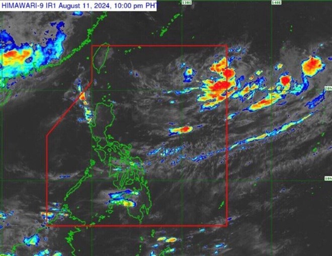
The latest storm and tropical depression information from the Philippine Atmospheric, Geophysical and Astronomical Services Administration (PAGASA) said that at 3:00 a.m. on August 12, the low pressure near the East Sea was 1,375 km east of Northern Luzon.
Previously, in the afternoon bulletin on August 11, PAGASA said that at 3:00 p.m. on the same day, the low pressure near the East Sea was about 850 km northeast of Northern Luzon in the Philippines.
In the context of the low pressure, the influence of the southwest monsoon, or habagat, continues to affect the weather in the Philippines.
The southwest monsoon is currently affecting Luzon and the western part of the Visayas, causing rain in the Ilocos, Benguet, Zambales and Bataan areas.
“Metro Manila, the rest of Luzon, Western Visayas and Negros Island are expected to experience partly cloudy to cloudy skies with scattered showers due to the southwest monsoon,” PAGASA said in its latest weather forecast.
The rest of the Philippines is expected to experience scattered showers or thunderstorms.
Also information about low pressure near the East Sea, the latest storm and tropical depression news from the Joint Typhoon Warning Center (JTWC) of the US Air Force and the US Navy said that this low pressure is over the Philippine Sea and has been forming since August 10.
According to JTWC storm forecasters, this low pressure near the East Sea is likely to strengthen into a tropical depression within the next 24 hours.
In early August, Philippine weather forecasters informed that 2-3 tropical storms are expected to form or enter the forecast area of the Philippines in August.
“This August, we expect 2 to 3 tropical storms to form or enter the forecast area of the Philippines,” said storm forecaster Obet Badrina of the Philippine Atmospheric, Geophysical and Astronomical Services Administration (PAGASA).
Typhoon forecaster Robert Badrina also added that there is a possibility of 13 to 16 storms entering the Philippines’ forecast area between now and the end of the year.
Earlier in July, two tropical storms, “Butchoy” (Storm No. 2 Prapiroon) and “Carina” (International name Gaemi), formed in the area around the South China Sea.
Tropical storms are entering the Philippines’ forecast area more than anywhere else in the world. With an average of 20 storms each year, eight or nine of them will hit the Philippines.
The peak of the typhoon season is from July to October, when nearly 70% of each season’s typhoons form during this time.