According to the latest storm information, there are currently two hurricanes and one major storm in the Pacific Ocean.
The Pacific Ocean has been a hotbed of storms this week, with two storms in the northeast and one in the northwest.
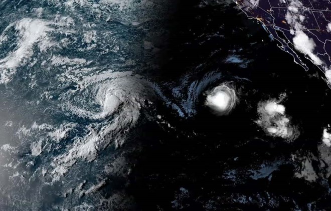
Hurricane Gilma rapidly strengthened into a Category 4 super typhoon on the Saffir-Simpson scale of five on August 25 as it moved west across the Pacific. Fortunately, Gilma’s path did not cause significant damage, but instead brought rough seas over the weekend. Waves as high as 12 feet (3.5 meters) and winds of up to 130 mph (209 km/h) posed a hazard to boats.
According to the latest forecast, Gilma will finally approach the US Hawaiian Islands, passing north of the islands on August 30. However, by then, Gilma is expected to have weakened to a low pressure area with minimal impact along the way.
In contrast, on August 25, Hurricane Hone made landfall in the Hawaiian Islands with maximum sustained winds of about 80 mph (129 km/h). Although classified as a Category 1 hurricane, Hone caused significant impacts due to rough seas with strong waves up to 14 feet (4.3 m) high and wind gusts of about 60 mph (96 km/h).
However, the greatest threat is flash flooding and landslides on steep slopes. Weather stations on the eastern side of the Big Island of Hawaii reported 4 inches (110 mm) of rain in the six hours from 9 p.m. on August 24. Several stations recorded as much as 250 mm of rain in the first 24 hours after the rains began, and one station in Mountain View, on the windward side of the island, recorded 350 mm of rain – nearly three times the average monthly rainfall for August.
While the two storms are moving in the northeast Pacific, Typhoon Shanshan is expected to make landfall in Japan today (27 August).
The Joint Typhoon Warning Center (JTWC) and the Japan Meteorological Agency (JMA) estimate maximum sustained winds of 139-148 km/h near the storm’s eye when it makes landfall in Kagoshima Prefecture on the southern tip of Kyushu.
The destructive potential of these winds poses a significant threat to infrastructure as the storm makes landfall. The accompanying heavy rainfall is equally worrying, with some weather models predicting more than 300 mm of rain around 29 August, increasing the risk of flash floods and landslides, especially in mountainous areas.


