Rumors of a super typhoon forming near the East Sea, larger than the area of the Philippines, are spreading on social media.
Rappler’s latest typhoon report says that according to a Facebook post, the Philippine Atmospheric, Geophysical and Astronomical Services Administration (PAGASA) is forecasting that a tropical storm larger than the Philippines will form in the Philippine forecast area (PAR) next week, the second week of September. Rappler stresses that this is false information.
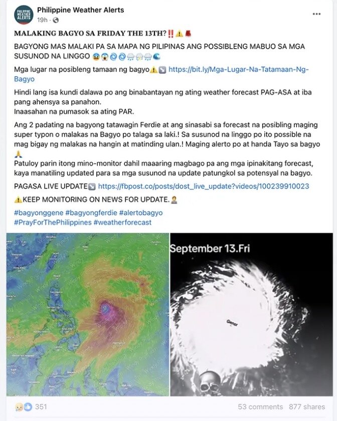
The Philippine news agency notes that the Facebook post about a super typhoon expected to appear near the South China Sea has 631 shares, 251 interactions and 38 comments. The post was posted by the account “Philippine Weather Alert”, which has 17,000 followers and 4,400 likes.
The post said that a tropical storm larger than the Philippines is expected to form in the Philippine forecast area in the second week of September. The post also stated that PAGASA is monitoring two storms that have the potential to become super typhoons.
Explaining why the information is false, Rappler pointed out that although PAGASA’s recent storm forecast mentioned the possibility of a low pressure area near the South China Sea entering the Philippine forecast area in the next two weeks, none of the systems are likely to be larger than Philippine territory. The storm level and expected intensity of these storms have not been determined.
According to PAGASA’s storm forecast for September 6, two low pressure areas near the South China Sea may form during the week from September 6 to 12. One low pressure area near the South China Sea may form north of the Philippine forecast area, while the other low pressure area may form outside the Philippine forecast area. Both of these low pressure areas have a high chance of strengthening into tropical storms.
During the week of September 13-19, a low pressure area that forms outside the forecast area is forecast to enter the Philippine forecast area and strengthen into a storm. Also during this week, a third low pressure area near the South China Sea may form near northwestern Luzon, with the possibility of strengthening into a storm.
PAGASA did not state in any of its storm or tropical depression forecasts that a super typhoon is expected near the South China Sea in the next two weeks.
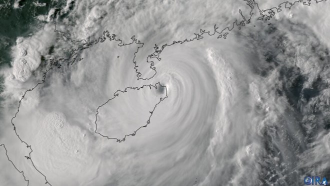
Storm No. 3 Yagi (local name Enteng), which left the Philippine forecast area on September 4, is the closest super typhoon PAGASA is tracking.
However, while inside the Philippine forecast area, Super Typhoon Yagi is only a strong tropical storm. This South China Sea storm will strengthen into a typhoon and super typhoon when it enters the South China Sea, outside the Philippine forecast area.
The post warning of a super typhoon approaching the East Sea also had a link claiming to be a list of areas affected by the super typhoon.
However, when scanned on the link checking website WhereGoes, the link warning of a super typhoon near the East Sea led to an online shopping platform, not a PAGASA typhoon forecast.
Similarly, when scanned on VirusTotal, the link in the post warning of a super typhoon was flagged as malicious. Certego and Criminal IP also detected potential phishing threats in the link warning of a super typhoon near the East Sea. Accessing such links puts users at risk of having their information stolen.


